Colonization and main settlements in XIX century California
We all know how frustrating research can be sometimes, especially when the story is so clear in one’s head, but you have a thousand doubts about minor details. In order to put an end to that particular sort of ordeal, please find below a list of minor things which might help, divided into categories.
In terms of historical context, for reasons of relevance, the data refers mainly (although not exclusively) to the period between 1815 and 1825.
Please note that all information below has been gathered from online public sources.
Part I – Introductory remarks
Located at the extreme limits of exploration and trade from Spain, the first Europeans to explore California were the members of the Spanish expedition led by Portuguese captain Juan Rodríguez Cabrillo, which entered San Diego Bay on September 28th, 1542, and reached as far north as San Miguel Island.
Claimed by Spain, the territory was initially referred to as ‘Las Californias’ since it was believed at the time to be formed by a series of islands.
Occupied by Indigenous populations living in groups of extended families of 100-150 before the Spanish claimed it, California remained mainly unsettled and unexplored for the next 234 years.
The first presidios and missions in Alta California (current US state of California) – those of San Diego and Monterey – were established at the order of the Spanish King Carlos III (who ruled between 1759 and 1788), in response to Russian Empress Ekaterina the Great’s plan to colonize California, as well as the British threat to lay claim to the territory.
In 1804 California was divided into Alta and Baja California, both provinces of New Spain (which in 1821 became Mexico).
Alta California’s southern point was San Diego, but its northern border was not clearly identified. However, its farthest Spanish settlements north were the Missions (La Mission de) San Rafael Arcángel (1817)/ San Francisco de Solano (1823), respectively.
Part II: Infrastructure
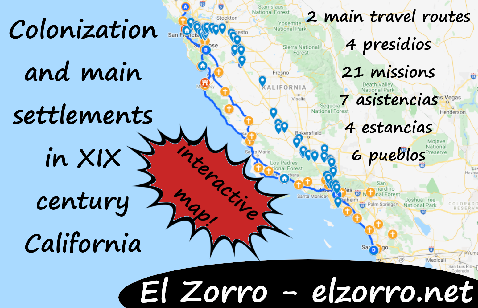
In the 1820s Alta California had:
- 4 presidios
- 21 missions
- 7 asistencias
- 4 estancias
- 6 pueblos
- 2 main travel routes
4 presidios – military forts
- San Diego (1769; the pueblo by the same name was settled from 1774 onwards);
- Monterey (capital – 1770; a pueblo developed around the presidio as the initial population, grew);
- San Francisco (1776; a pueblo started developing later);
- Santa Barbara (1780; a pueblo started developing later).
21 Missions – religious missionary centres
They were founded by the Franciscans, all of them Roman Catholic.
The missions also included living quarters mainly for the clergy and the converted natives/ so-called; neophytes, large estates meant for farming, raising animals, and workshops.
Their main workforce was constituted by neophytes and their lands were considered to belong to the natives but were later mostly confiscated by the Mexicans after the mission system was abolished.
Some of the missions and asistencias were in their early days the scene of revolts and attacks by the natives, incidences of torture and executions, epidemics which decimated the number of those living there, and many of the priests were known for their abuses against the converts.
The number of neophytes living at the missions (or, more precisely, in nearby villages) many times surpassed 1000 people at the time. By comparison, LA’s population in 1820 was, officially, around 300 people.
7 Asistencias – branch missions
They included a chapel, living quarters, workshops and crops, normally established near native villages
4 Estancias – landholdings/ farms
They were usually consisting of a house and stables, but also benefiting from a chapel aimed at converting natives to Christianity
Missions, asistencias and estancias list
The list below includes all missions, asistencias and estancias known to have existed at the time, listed from north to south:
- Mission San Francisco Solano (1823)
- Mission San Rafael Arcángel (1817)
- Mission San Francisco de Asís (Mission Dolores) (1776)
- Mission Dolores Asistencia (1797 – located in San Mateo);
- San Pedro y San Pablo Asistencia (1786 – located in San Pedro Valley);
- Mission San José (1797)
- Mission Santa Clara de Asís (1777)
- Mission Santa Cruz (1791)
- Mission San Juan Bautista (1797)
- Mission San Carlos Borromeo de Carmelo (1770)
- Mission Nuestra Señora de la Soledad (1791)
- Mission San Antonio de Padua (1771)
- Mission San Miguel Arcángel (1797)
- Mission San Luis Obispo de Tolosa (1772)
- Santa Margarita de Cortona Asistencia (1787 – located in Santa Margarita)
- Mission La Purísima Concepción (1787)
- Mission Santa Inés (1804)
- Mission Santa Barbara (1786)
- Mission San Buenaventura (1782)
- Santa Paula Asistencia (year unknown although the campsite dates back to 1769, probably not long after the Mission was built – located 20 miles west of the Mission, in what is now Santa Paula)
- Mission San Fernando Rey de España (1797)
- Estancia de San Francisco Xavier (1804 – located around current Santa Clarita)
- Mission San Gabriel Arcángel (1771)
- Nuestra Señora Reina de los Angeles Asistencia (1784 – located in Los Angeles) which stopped being used, and was later (1814) replaced by La Iglesia de Nuestra Señora Reina de los Ángeles (the Church of Our Lady Queen of the Angels)
- San Bernardino de Sena Estancia (1819 – Located in what became San Bernardino)
- Mission San Juan Capistrano (1776)
- Diego Sepúlveda Adobe (known also as Costa Mesa Estancia, and, later, as Santa Ana Estancia) (1817 – was 15 miles north of Mission San Juan Capistrano)
- Mission San Luis Rey de Francia (1798)
- San Antonio de Pala Asistencia/ Pala Mission (1816 – located about twenty miles inland, on the San Luis Rey River)
- The Las Flores Estancia (also known as Las Flores Asistencia) (officially 1823 although a farming outpost is known to have existed there since 1810; located halfway between Mission San Luis Rey de Francia and Mission San Juan Capistrano, near current Bell Canyon, ten miles south of the City of San Clemente)
- Mission San Diego de Alcalá (1769)
- Santa Ysabel Asistencia (1818 – Cañada de Santa Ysabel in the mountains east of San Diego)
6 pueblos – villages
They were mostly referred to as towns, although their population barely reached between 100 and 400 people in 1820 (listed below from north to south).
- San Francisco (1776);
- San José (1777) – Officially founded as California’s first civilian settlement on November 29th, 1777, as the Pueblo de San José de Guadalupe;
- Villa de Branciforte (1797) – Officially founded as the third and last Spanish civilian settlement in California, it never prospered, although it endured;
- Santa Barbara (1786),
- Los Angeles (1781) – Officially founded as California’s second civilian settlement on September 4th, 1781, established as El Pueblo de Nuestra Señora la Reina de los Ángeles by 44 settlers from New Spain who headed there departing from the Mission San Gabriel Arcángel;
- San Diego (1769, colonized after 1774).
2 main travel routes
With a view to facilitate travel on land, the 600 mile-long (970 km) Camino Real (en. Royal Road) was built. For the same purpose, the Mission settlements were situated about 30 miles (48 km) apart along the Camino Real, a distance which constituted about a day’s ride on horseback.
As an alternative to Camino Real, El Camino Viejo a Los Angeles/ Old Spanish Trail to Los Angeles united the mentioned pueblo to San Francisco in the north, and was the oldest north-south trail in the interior of California, used between 1769-1848.
It ran from San Pedro Bay, over the Tejon Pass and the eastern slopes of the coastal range, splitting at Solo Springs. The eastern bypass went along the Laguna de Tache (now Tulare Lake), north to the San Joaquin River, then again merged with the western trail at Arroyo de Panoche Grande. The western trail went past Avenal and east of Coalinga. After the two routes rejoined, the trail continued through Valle de San Jose and the nearby passes, ending at the strait of San Francisco Bay.
By 1820 the Camino Viejo was mainly used by Native Americans, vaqueros driving herds of cattle and horses, trappers and prospectors. It was also a favourite spot for bandits, cattle and horse thieves to attack, taking advantage of the isolation along the road and the fact that the Royal (and, later, Mexican) armed forces concentrated their efforts along El Camino Real.
Joaquin Murietta, Tiburcio Vasquez, and Procopio (who all partly inspired the creation of the character Zorro, although, as Mexicans, they had not fought against Spain but against the injustices committed by the Americans against the Mexicans in California after the annexation), also mainly operated around the Camino Viejo.
XIX century California on interactive maps
Click here for Google Earth visualisation (pins are as close as possible near original locations): https://earth.google.com/earth/d/16SszLFBK_pwVxdeDS4KjXkknpeUZbmvk?usp=sharing or try Google Maps:
legend:
missions and estates – yellow cross, military presidios – red castle, pueblos – blue house, points in El Camino Viejo – blue pointers, El Camino Real – blue roads
Main sources
- Gale McGovern, Carolyn: “Hispanic population in Alta California: 1790 and the 1830’s” (1978)
- https://en.wikipedia.org/wiki/History_of_California
- https://en.wikipedia.org/wiki/History_of_California_before_1900
- https://en.wikipedia.org/wiki/List_of_Spanish_missions_in_California
- http://www.mylemooreleader.com/127237
- https://en.wikipedia.org/wiki/List_of_governors_of_California_before_1850
- https://californiamissionsfoundation.org/asistencias/
- http://www.missiontrailtoday.com/code/mission_ae.htm
This is awesome information that helps set the stories in real places. Thank you for this.